"...inexpressibly comprehensive, grand, and picturesque. After congratulating ourselves upon the safe achievement of our morning feat, and breathing our mules a few minutes, we proceeded on our journey. A mile brought us to a small dimple on top of the mountain, in the centre of which is a miniature lake, surrounded by green grass."
from What I saw in California by Edwin Bryant in 1849 upon reaching Donner Summit
Donner Summit is grand and unique and the Donner Summit Historical Society's 20 Mile Museum highlights the history and beauty of the Summit.
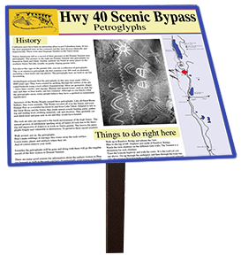
Interpretive signs have been placed mostly along Old Highway 40 and nearby from Auburn to Truckee. Each sign highlights history, displays historical photographs and quotes, tells a good story, and lists activities for that location. As of the beginning of 2016 there are 45 20 Mile Museum signs.The map to the right show the approximate locations.
The Museum has met with overwhelming community approval and support. Each sign, is sponsored by local businesses or individuals.
The next page will open any of the signs you would like to look up as PDF's. The actual signs are two feet square. The PDF's however have been reduced in size and resolution to enable easy uploading.
Link to brochure pg 1 PDF 18" wide
Link to brochure pg 2 PDF 18" wide
link to text only PDF
link to the scrollable version for smart phones.
Here also is a .gpx file download for use with your GPS in finding the 20 Mile Museum signs. This comes from Randy Hodges --- GPX file
 Commercial Sponsors:
The Summit Restaurant,
Royal Gorge,
Soda Springs Store,
Sugar Bowl,
Boreal,
Soda Springs Ski Area,
Donner Spitz,
Clair Tappaan,
Donner Summit Area Association
Nyack
Truckee Donner Land Trust